 Photo: BC Parks
 Sx̱ótsaqel / Chilliwack Lake Park
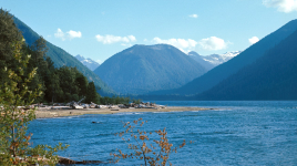
BC Parks inside Sx̱ótsaqel / CHILLIWACK LAKE PARKwhat to expect
Located 150 km east of Vancouver in the upper Chilliwack River Valley, S⨱ótsaqel / Chilliwack Lake Park is characterized by a valley-bottom lake, old-growth forested slopes, and spectacular subalpine and alpine ridges. The sparkling Chilliwack Lake is ideal for motorboating, canoeing, kayaking, swimming, or fishing. There are opportunities for hiking, bird and wildlife viewing, and nature appreciation on the 40 km of trails in the park. The park also has a playground and 182 frontcountry campsites. Those seeking a wilderness camping experience can access the backcountry camps located at Greendrop, Lindeman, Flora, and Radium Lakes.
Description: BC Parks
the campsites
things to do here
Activities you can do at Sx̱ótsaqel / Chilliwack Lake Park.
things to do nearby
Within 5 km — trails, viewpoints, beaches, boat launches you can reach without packing up camp.
- Radium Lake Trailhead
- Radium Lake Trailhead
- Radium Lake
- Chilliwack Lake
- Porcupine Rock
- Lindeman Wall
- Flora Lake Lookout
- Lindeman Lake
Plus 6 user-tagged viewpoints, 3 user-tagged beaches, 2 user-tagged trailheads, 1 user-tagged boat launch on OpenStreetMap — visible as pins on the map below.
what's around
Sx̱ótsaqel / Chilliwack Lake Park plus 8 named places to see and do nearby — trails, beaches, viewpoints, water, and services.
water + services
- Nearest dump station
- Nearest potable water
what to know
Updated each morning from provincial parks and Environment Canada.
other campgrounds nearby
Other places to stay within 25 km.
- Flora Lake Camp
- Chilliwack Lake Camp
- Greendrop Lake Camp
- Riverside
- Riverside Campground
- North Foley Lake
- South Foley Lake
- Airplane Creek
Plus 14 user-tagged dispersed sites on OpenStreetMap — often genuine wild-pitches; check access rights before relying on one.
keep an eye on Sx̱ótsaqel / Chilliwack Lake Park
Every Thursday we send the weekend list: which campgrounds still have sites for the coming weekend, plus fire bans and new conditions. We’ll tag you to this park so its alerts reach you first as they roll out.
One email. Unsubscribe anytime. We don’t share addresses. — [email protected]