 Photo: BC Parks
 Saltery Bay Provincial Park
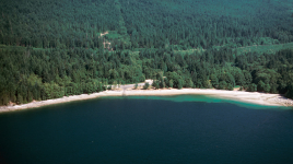
BC Parks inside Saltery Bay Parkwhat to expect
Saltery Bay Park was established in 1962 to provide ocean access on the Sunshine Coast of Georgia Strait. The park is divided into two separate sites: the campground and the day-use area. The day-use area with its rocky beaches is a popular swimming and picnic site. Lush forests with large, old trees create a quiet setting for the campground at Mermaid Cove. At low tide, the rocky shoreline often has tidal pools with starfish, sea urchins, small fish and crabs. Scuba diving provides a close-up look at the abundant marine life and a 3 m bronze mermaid statue. The Emerald Princess statue and wheelchair access ramp were placed in the park through efforts of local scuba enthusiasts. From the shore, killer whales and sea lions can sometimes be seen. Mounds of seashells called “middens” indica…
Description: BC Parks
the basics
find more: campgrounds with showers near here →
the campsites
things to do here
Activities you can do at Saltery Bay Provincial Park.
things to do nearby
Within 5 km — trails, viewpoints, beaches, boat launches you can reach without packing up camp.
- Saltery Bay
- Sunshine Coast
- Rose Beach
- Rose Beach
- Pirates' Cove
- Rainy Day Lake
- Hailstone Bluff
- Elephant Lake
Plus 3 user-tagged boat launches, 1 user-tagged beach on OpenStreetMap — visible as pins on the map below.
what's around
Saltery Bay Provincial Park plus 8 named places to see and do nearby — trails, beaches, viewpoints, water, and services.
water + services
2 user-tagged dump stations on OpenStreetMap.
what to know
Updated each morning from provincial parks and Environment Canada.
other campgrounds nearby
Other places to stay within 25 km.
- Saltery Bay Provincial Picnic Park
- RV by the Sea, Saltery Bay Ferry
- Kent's Beach Resort
- Troubridge Hut
- Rainy Day Lake Hut
- Fairview Bay Hut
- Golden Stanley Hut
- Lois Point Recreation Site
Plus 9 user-tagged dispersed sites on OpenStreetMap — often genuine wild-pitches; check access rights before relying on one.
keep an eye on Saltery Bay Provincial Park
Every Thursday we send the weekend list: which campgrounds still have sites for the coming weekend, plus fire bans and new conditions. We’ll tag you to this park so its alerts reach you first as they roll out.
One email. Unsubscribe anytime. We don’t share addresses. — [email protected]