 Photo: Ontario Parks
 Port Burwell Provincial Park
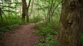
Ontario Parks inside Port Burwell Provincial Parkwhat to expect
Port Burwell Provincial Park offers both day use and camping opportunities. Located on the northern shore of Lake Erie, it hosts 2.5 km of sandy beach, one hiking trail, and excellent birding opportunities. Port Burwell includes three campgrounds: Alzora Campground has an array of campsites located throughout mixed deciduous and conifer stands, with some sites located right along the Ravine Creek. This campground is conveniently adjacent to the Recreation Field with easy access to the Interpretive Centre and playground. Leander Campground , is centrally located in the park. With its proximity to the playground, it is the most popular for families with young children. Campsites are decently sized and are fairly private, with most being sunny and grass covered. Iroquois Campground offe…
Description: Ontario Parks
the campsites
things to do here
Activities you can do at Port Burwell Provincial Park.
things to do nearby
Within 5 km — trails, viewpoints, beaches, boat launches you can reach without packing up camp.
- Port Burwell West Beach (Provincial)
- Port Burwell
- Port Burwell
- Port Burwell
- Port Burwell East Beach (Municipal)
- Port Burwell Nude Beach
Plus 2 user-tagged viewpoints on OpenStreetMap — visible as pins on the map below.
what's around
Port Burwell Provincial Park plus 6 named places to see and do nearby — trails, beaches, viewpoints, water, and services.
water + services
- Nearest dump station
- Nearest potable water
what to know
Updated each morning from provincial parks and Environment Canada.
other campgrounds nearby
Other places to stay within 25 km.
- Port Burwell Provincial Park - Alzora Campground
- Port Burwell Provincial Park - Group Campground
- Port Burwell Provincial Park - Leander Campground
- Port Burwell Provincial Park - Iroquois Campground
- Big Otter Marina & Campground
- Otter’s Edge Estates
- Trailer park
- John Paul II Family Centre
Plus 5 user-tagged dispersed sites on OpenStreetMap — often genuine wild-pitches; check access rights before relying on one.
keep an eye on Port Burwell Provincial Park
Every Thursday we send the weekend list: which campgrounds still have sites for the coming weekend, plus fire bans and new conditions. We’ll tag you to this park so its alerts reach you first as they roll out.
One email. Unsubscribe anytime. We don’t share addresses. — [email protected]