 Photo: BC Parks
 Kettle River Recreation Area
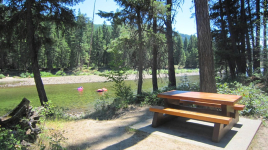
BC Parks inside Kettle River Recreation Areawhat to expect
Stands of Ponderosa pine interspersed with open areas of bunchgrass characterize this recreation area that lies astride the Kettle River. This park is situated between the Okanagan Plateau and the Monashee Mountains. The abandoned right-of-way of the historic Kettle Valley section of the Canadian Pacific Railway, completed in 1916 to link the Pacific coast with southern Alberta, passes through the site. On the east bank of the river is evidence of the once flourishing gold and silver mines. In the summer, excellent canoeing or inner tube riding although there are some hazards on the river. In the winter, cross-country skiing and snowshoeing are favourite pastimes.
Description: BC Parks
the basics
find more: campgrounds with playgrounds near here → ·campgrounds with showers near here →
the campsites
things to do here
Activities you can do at Kettle River Recreation Area.
water + services
8 user-tagged water sources on OpenStreetMap.
what to know
Updated each morning from provincial parks and Environment Canada.
other campgrounds nearby
Other places to stay within 25 km.
- Kettle Creek Campground
- Rock Creek Riverside Campground
- Rock Creek Station (incl. General Store)
- Blaine Memorial Campground
- Kettle River Prov Rec Area
- THE CODDIEWOMPLERS
- Johnstone Creek Campground
- Little Dipper Campground
Plus 4 user-tagged dispersed sites on OpenStreetMap — often genuine wild-pitches; check access rights before relying on one.
keep an eye on Kettle River Recreation Area
Every Thursday we send the weekend list: which campgrounds still have sites for the coming weekend, plus fire bans and new conditions. We’ll tag you to this park so its alerts reach you first as they roll out.
One email. Unsubscribe anytime. We don’t share addresses. — [email protected]