 Photo: BC Parks
 Kekuli Bay Provincial Park
BC Parks inside Kekuli Bay Parkwhat to expect
Kekuli Bay Park is located off Highway 97, 11km. south of Vernon. The park is situated on a beautiful bay on the west side of Kalamalka Lake, a destination for waterskiing and boating. A newly developed campground has been added to the area which formerly consisted only of a boat launch. Many young shade trees were planted and the grassy areas between the sites are beautifully landscaped. The young trees planted 10 years ago have begun to mature and provide shade and privacy around the sites, especially on the upper loops. There are irrigated grassy areas between the sites full of beautiful trees and shrubs including rose bushes that are in full bloom during the spring. All campsites offer great views of Kalamalka Lake and offer the warmth of the sun in the spring and fall.
Description: BC Parks
the basics
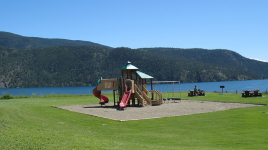
find more: campgrounds with playgrounds near here → ·campgrounds with pet-friendly sites near here → ·campgrounds with showers near here →
the campsites
things to do here
Activities you can do at Kekuli Bay Provincial Park.
things to do nearby
Within 5 km — trails, viewpoints, beaches, boat launches you can reach without packing up camp.
- Bench
- Kalamalka Lake
Plus 3 user-tagged viewpoints, 2 user-tagged boat launches, 1 user-tagged beach on OpenStreetMap — visible as pins on the map below.
what's around
Kekuli Bay Provincial Park plus 2 named places to see and do nearby — trails, beaches, viewpoints, water, and services.
water + services
- Nearest dump station
3 user-tagged water sources on OpenStreetMap.
what to know
Updated each morning from provincial parks and Environment Canada.
other campgrounds nearby
Other places to stay within 25 km — ones with openings in the next 14 days first.
- Ellison Provincial Park limited openings
- Private Campground
- Klub Kalamalka
- Sandy Beach RV Park
- Damer Lake
- Dutch's Campground
- Big Chief RV Park
- High Lake
Plus 13 user-tagged dispersed sites on OpenStreetMap — often genuine wild-pitches; check access rights before relying on one.
keep an eye on Kekuli Bay Provincial Park
Every Thursday we send the weekend list: which campgrounds still have sites for the coming weekend, plus fire bans and new conditions. We’ll tag you to this park so its alerts reach you first as they roll out.
One email. Unsubscribe anytime. We don’t share addresses. — [email protected]