 Photo: BC Parks
 Bamberton Provincial Park
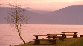
BC Parks inside Bamberton Parkwhat to expect
The inviting water and the 225 metre long sandy beach have made Bamberton Park an ideal spot for visitors. Frolic in the warm waves, lounge in the sand and enjoy the views across the inlet. To the east are the shores of the Saanich Peninsula, with the southern Gulf Islands and Mt. Baker beyond. Rising sharply to the west are the mountains of south Vancouver Island. A vehicle-accessible campground is nestled in this forest environment, where eagles and osprey can be seen circling high above. Waterfowl and seals are frequent visitors to the surrounding waters. The park is very popular in the summer months, and can be busy as well in June, when a number of nearby schools make field trips to study the intertidal life on the beach. With Victoria just a 30 minute drive south over the scenic Ma…
Description: BC Parks
the basics
the campsites
things to do here
Activities you can do at Bamberton Provincial Park.
things to do nearby
Within 5 km — trails, viewpoints, beaches, boat launches you can reach without packing up camp.
- Oliphant Lake
- Rat Lake
- Spectacle Lake
Plus 5 user-tagged viewpoints, 1 user-tagged beach on OpenStreetMap — visible as pins on the map below.
what's around
Bamberton Provincial Park plus 3 named places to see and do nearby — trails, beaches, viewpoints, water, and services.
water + services
- Nearest dump station
7 user-tagged water sources on OpenStreetMap.
what to know
Updated each morning from provincial parks and Environment Canada.
other campgrounds nearby
Other places to stay within 25 km — ones with openings in the next 14 days first.
- Gulf Islands - SMONEĆTEN openings
- Beehive RV Park & Campground
- KOA Victoria West
- Cedar Springs Ranch
- Sol Sante Club
- Malahat Mountain Meadows RV Resort
- Smonećten (McDonald) Campground
- Ocean Winds RV Park
Plus 3 user-tagged dispersed sites on OpenStreetMap — often genuine wild-pitches; check access rights before relying on one.
keep an eye on Bamberton Provincial Park
Every Thursday we send the weekend list: which campgrounds still have sites for the coming weekend, plus fire bans and new conditions. We’ll tag you to this park so its alerts reach you first as they roll out.
One email. Unsubscribe anytime. We don’t share addresses. — [email protected]